Free Travel App

RING
GUIDE.

Everything worth knowing around the legendary Eifel racing circuit, on one map. Hand-picked places, the best driving roads, and a map you can download before you travel, so it still draws when the signal doesn't.
Download on theApp Store Coming soon toGoogle Play
Free, no ads No account needed iPhone & iPad
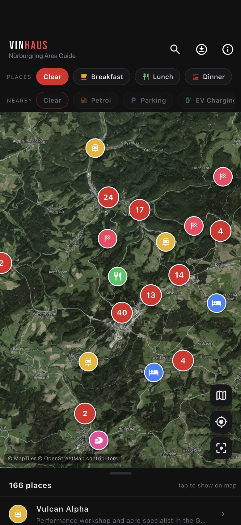
Ring Guide map screen showing clustered place markers over satellite imagery of the Eifel
Scroll
166
Hand-picked places
across 18 categories
17
Driving routes
drawn on the map
14
Trip info sections
written for first-timers
6,291
Nearby fuel, parking,
viewpoints & more
What's inside

Built for
the trip.

Not a scraped directory. Every place is picked, described and pinned by hand, then wrapped in the things you actually need at 07:00 with a full car park and no phone signal.

One interactive map
Every place on a single map with satellite or dark street view. Dense areas cluster into a count bubble, so it stays readable at any zoom.
The map works offline
Download the region before you go and the map, the pins, the descriptions and the drive lines all still load with no signal. Directions and websites hand off to other apps, so those still need one.
Filter by what you need
Breakfast, lunch, dinner, vegan, coffee, hotels, sights, track spots, garages and more. Tap a category, the map and list follow.
The good roads
17 driving routes traced on the map, from the Vulkanstraße to the quiet stuff. Tap one and it draws the whole run, so you can see where it goes before you commit.
Trip info that matters
Emergency numbers, lap tickets, insurance gaps, etiquette, what to bring and what to do if it all goes wrong. Read it before you drive.
Hands off to your maps app
Every place opens in Maps or Waze for the actual navigating, with a phone number, website and share button where we have them. There's no sat nav built in, and those handoffs need a signal.
Nearby essentials
Thousands of fuel stations, car parks, EV chargers, viewpoints, campsites and bars layered on top when you need them.
Nothing collected
No account, no sign-up, no tracking. Location stays on your device and is only used to show where you are.
A look inside

Three taps
to sorted.

Open the map, filter to what you're after, tap through to see what it is.
Map screen with clustered markers over Eifel satellite imagery
MapSatellite or dark street view, with pins clustered so it never turns to soup.
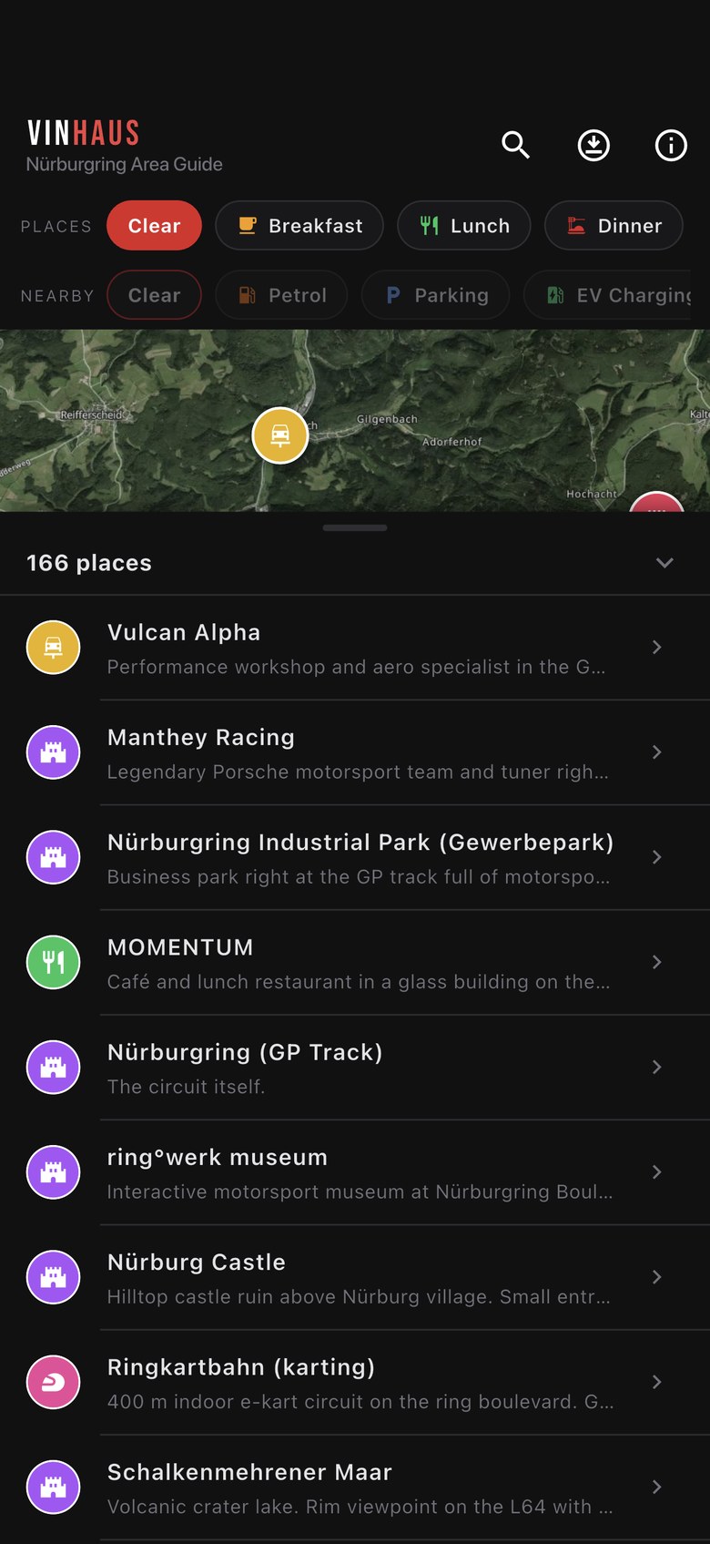
Scrollable list of places with category icons and descriptions
ListDrag the sheet up to browse everything on screen. Tap to fly to it.
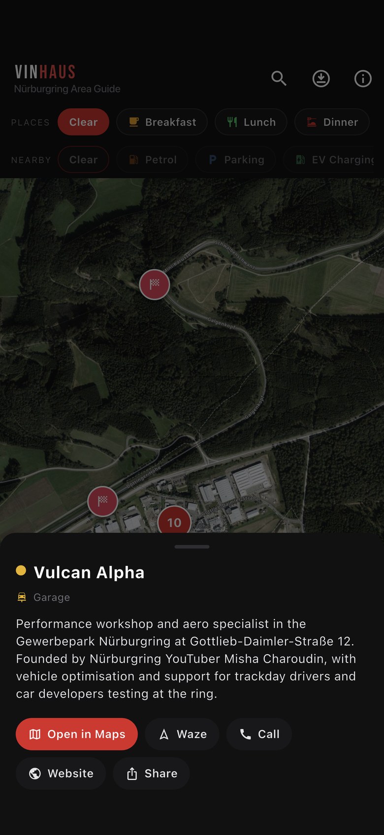
Place detail sheet with description and Open in Maps, Waze, Website and Share buttons
DetailsWhat it is, why it's worth it, and a one-tap handoff to your maps app.
Offline, honestly

Where the
signal ends.

The Eifel is beautiful and the coverage is not. Download the region before you leave and the map still draws in a valley with one bar. Worth being straight about where that stops, though: Ring Guide shows you where everything is, it isn't a sat nav.

  • Works with no signalThe map, every pin and description, the drive lines and the trip info. It's all on your phone.
  • Needs a signalOpen in Maps, Waze, websites, TripAdvisor and booking links. They hand off to other apps.
  • There's no navigation in the app. Getting there is your usual maps app, or the old-fashioned way.
  • Roughly 20 MB a layer, satellite or street, downloaded over Wi-Fi in a couple of minutes. Clear it any time.
Activities 19 Dinner 19 Track spots 18 Drives & Views 17 Hotels 13 Sights 12 Garage 11 Lunch 10 Coffee 9 Shops 7 Towns 6 Breakfast 6 Vegan 5 Nightlife 4 Bike hire 3 Parking 3 Car Wash 2 Cash 2

Every category in the app, with the number of places in each.

Before you go

Three steps.

Do this on the sofa, not in a lay-by outside Adenau.

01
Install it
Free on the App Store. No account, no sign-up, no email. Open it and the map is already there.
02
Download the maps
Open Offline maps from the info screen and pull the region down over Wi-Fi. About 20 MB, and the map then draws with no signal.
03
Read the trip info
Fourteen sections on lap tickets, insurance, etiquette and what to do after a shunt. Worth ten minutes.
Questions

FAQ

Yes. Free to download, no ads, no subscription, nothing to unlock.
It's in the works. The app is built to run on both, and the Play Store listing is coming. There's no date yet, so nothing to sign up to just now.
The reference side of it does. Once you've downloaded the region, the map, every pin and description, the 17 drive routes and all the trip info work with no signal, because they live on your phone. What doesn't is anything that leaves the app: Open in Maps, Waze, websites, TripAdvisor and booking links all need a connection. There's no turn-by-turn navigation built in either. Ring Guide is there to show you where everything is and help you plan. The actual navigating is your maps app, or a paper map and some common sense.
Neither. There's no account and no analytics. If you grant location permission it's used on your device to show your position on the map, and it isn't sent anywhere. See the privacy policy.
An iPhone or iPad on iOS 13 or later. The app is about 27 MB, plus roughly 20 MB for each map layer you save for offline use.
Please do. Email support@vinhaus.co.uk with the place or the problem and we'll get it into the next data refresh.
No. Ring Guide is an independent travel guide made by enthusiasts. It isn't affiliated with, endorsed by, or connected to any circuit operator or trademark holder. Always check official sources for opening times, prices and closures.

Get it
free.

166 places, 17 drives and a map you can take out of signal.

Download on theApp Store Coming soon toGoogle Play